Graphic Resource - Tending Zones in a Farming System
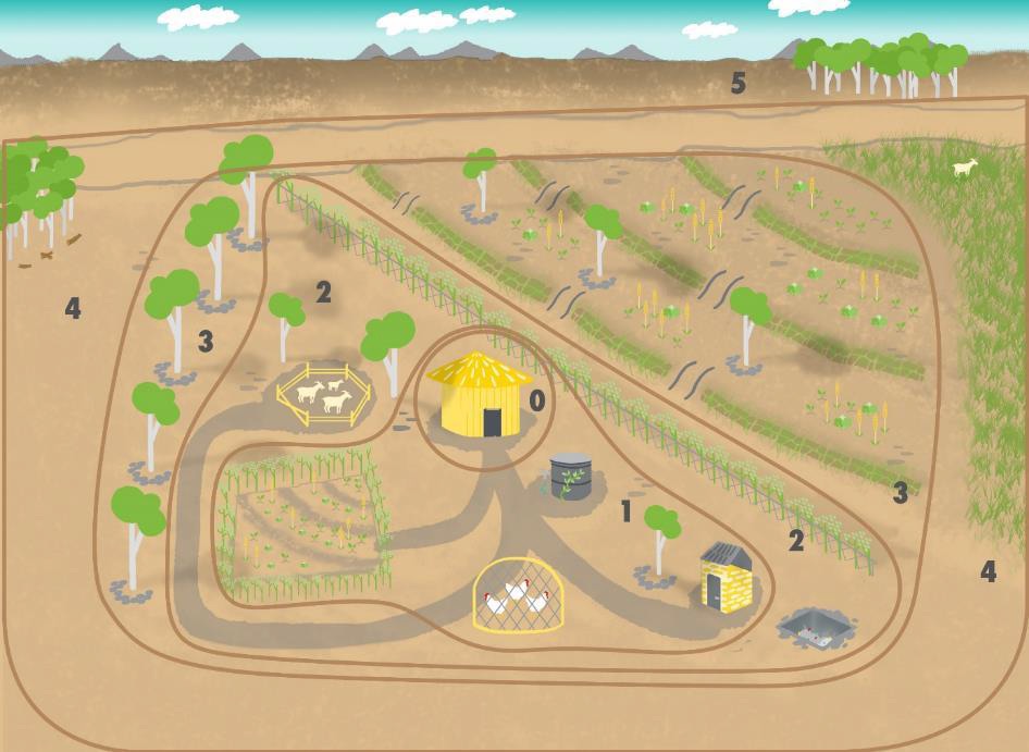
This is a schematic diagram, in reality zones are irregular shapes with no clearly defined borders. Zones may even be separated physically from one another, for example in the case of a smallholder farm that consists of parcels of land in different places. Paths and movement corridors can also be considered zones and special attention should be paid to them.
Zone O is the center of the farm, typically where the house is located.
Zone 1 then consists of the most visited areas close to the house or possibly along a frequently travelled path. Place everything that needs a lot of attention, or that farmers visit and tend often, in Zone 1. Permagardens, seedlings that require daily watering, frequently used herbs and vegetables, a chicken coop, and possibly a compost collection area are all examples that belong in Zone 1. For example, a farmer may locate a seedling-growing area along a route from the house to the chicken coop so that she can water seedlings at the same time as the daily egg collection; this both reduces energy expenditure and also minimizes the chance of forgetting to water. If the farmer rarely visits one side of the house, it would not be part of tending Zone 1 no matter how close to the house it is.
Zone 2 also receives a lot of attention, but less than Zone 1. It might contain smaller fruit trees, shrubs and trellised fruit, hedges, ponds and windbreaks. Zone 2 includes crops, livestock or other elements that do well without daily supervision or work, such as hardy perennial herbs and spices, and vegetables that take a long time to mature and are only picked once or twice. This area is densely planted and, where possible, should be mulched. It may also contain livestock such as goats and pigeons.
Zone 3 is still a managed tending zone, but not as intensively and the farmer does not visit it on a regular basis. It includes the main crop fields, large fruit and nut trees, and pastures for grazing cows, goats, and sheep, and keeping bees.
Zone 4 is only semi-managed and is an area for gathering wild foods and growing timber. Farmers can use this zone for managed grazing and it may contain livestock watering holes.
Zone 5 is not actively managed and would include bush land and possibly forest. Like Zone 4, it might also be an area for gathering wild foods and occasional grazing, as well as for natural livestock watering holes. There may be restrictions on access to areas